


Dolce-Via Sud

JackyCouturier
User
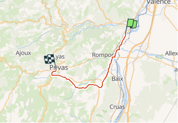

Length
29 km

Max alt
306 m

Uphill gradient
442 m
Km-Effort
34 km

Min alt
86 m

Downhill gradient
239 m
Boucle
No
Creation date :
2020-12-31 16:41:53.6
Updated on :
2020-12-31 17:04:39.419
--
Difficulty : Easy

FREE GPS app for hiking
 SityTrail
IGN / Geographical institutes
SityTrail Plus
The world is yours!
About
Trail Cycle of 29 km to be discovered at Auvergne-Rhône-Alpes, Ardèche, La Voulte-sur-Rhône. This trail is proposed by JackyCouturier.
Positioning
Country:
France
Region :
Auvergne-Rhône-Alpes
Department/Province :
Ardèche
Municipality :
La Voulte-sur-Rhône
Location:
Unknown
Start:(Dec)
Start:(UTM)
641046 ; 4962396 (31T) N.
Comments